Take the Survey
Download Master Plan
Participate
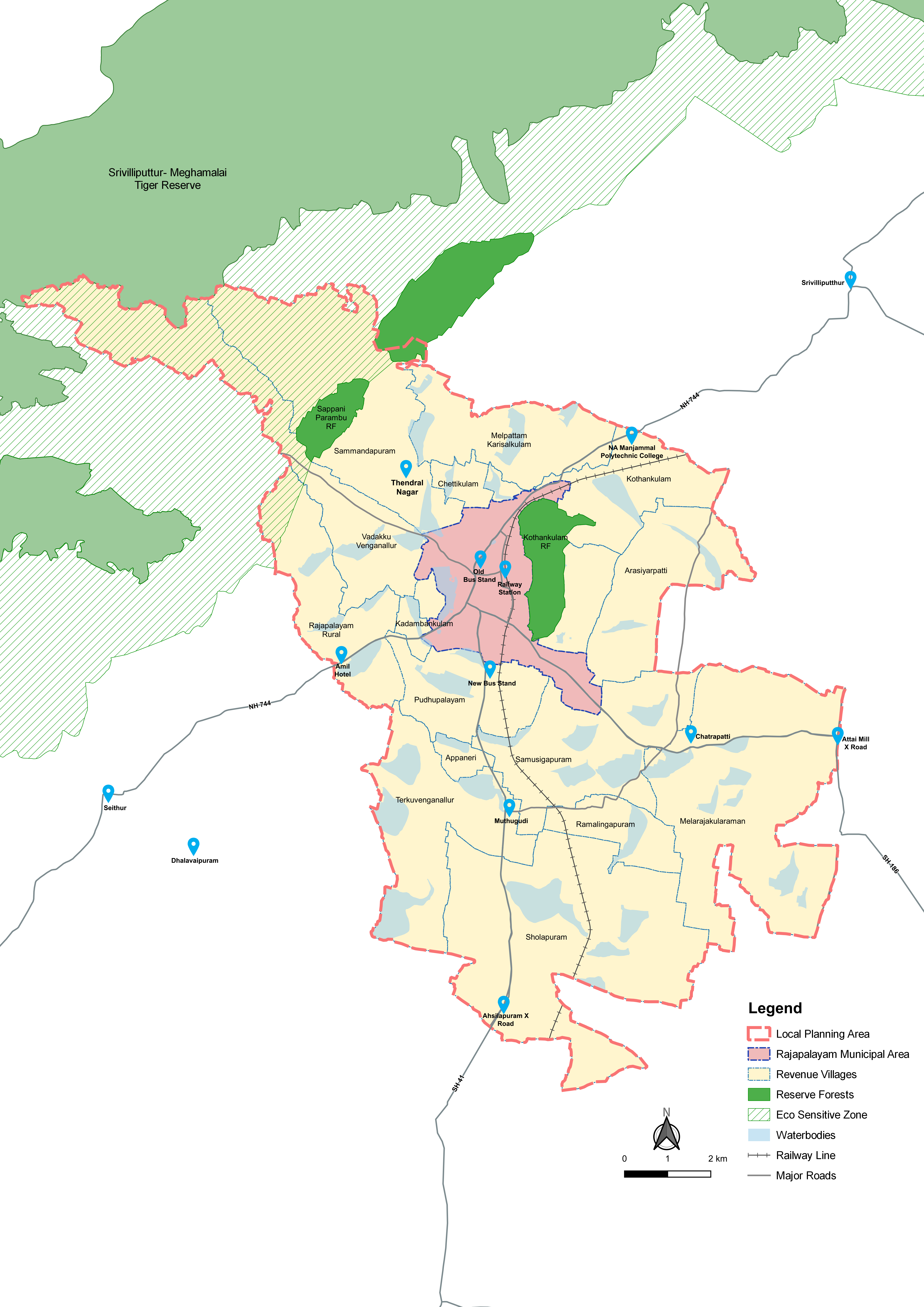
Know Your LPA
Revenue Villages
15
Reserve Forests
+ 2
Municipal Area
+ 1
Total LPA Area
149.06 Sq.Km
Total LPA Population
2,16,442
Municipal Area
9.59 Sq.Km (6.4% of LPA)
Municipal Area Population
1,30,442
6.4 % of area holds 60% of Population Currently
Population Density – LPA
1,452/ Sq.Km
Population Density – Municipal Area
13,602/
Sq.Km
Sex Ratio
1,005
Literacy Rate
75%
(2011 Census)
42 Waterbodies covering 13.3% (19.85 Sq.Km) of LPA
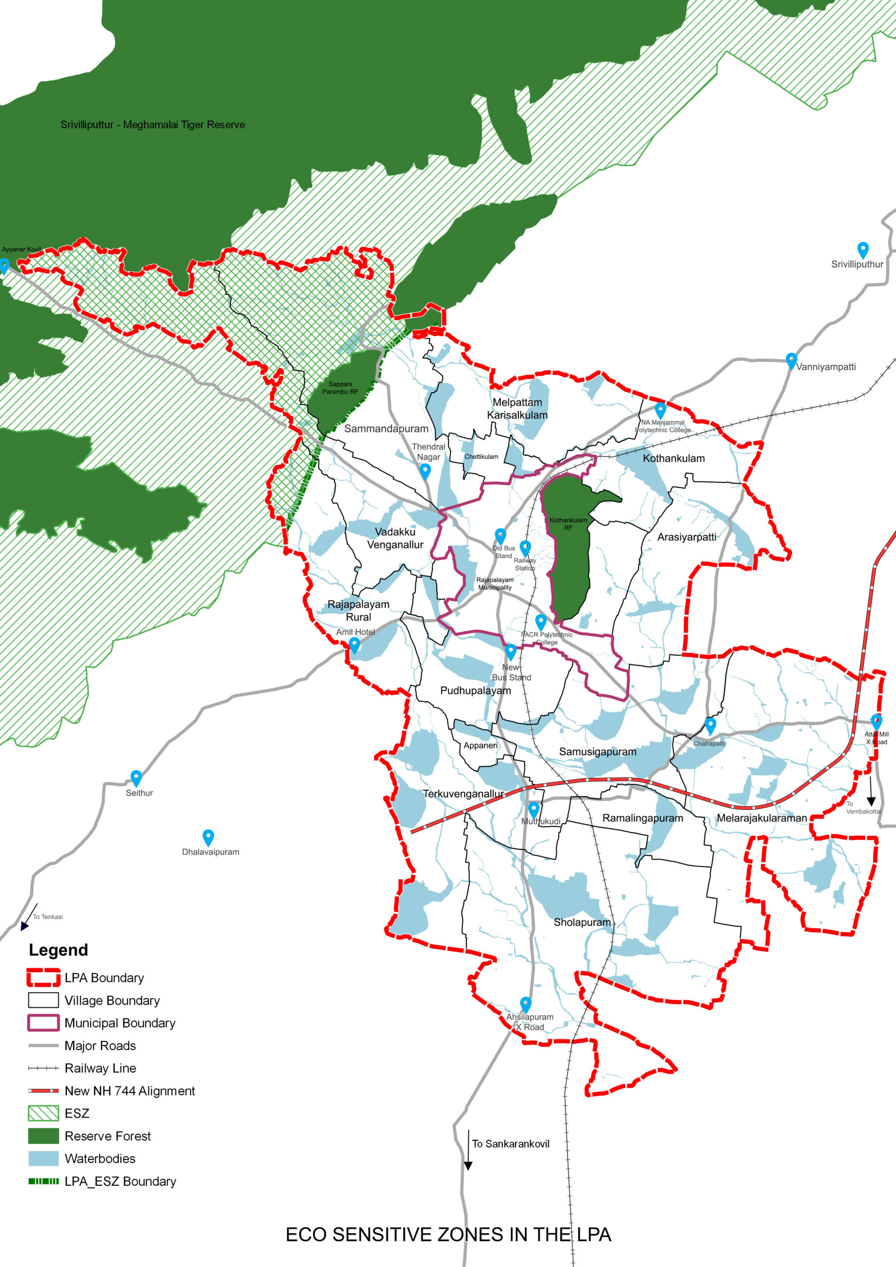
Eco Sensitive Zone for Srivilliputhur-Meghamalai Tiger Reserve (SMTR) covers
10.85% (16.23 Sq.Km) of LPA
2 Reserved Forests covering 3.1% (4.59 Sq.Km)
252 types of floral species & 399 faunal species identified
Active Agricultural Land – 47.10 Sq.Km ( 31%)
Master Plan
What is a Master Plan?
The Tamil Nadu Town and Country Planning Act, 1971, an Act to provide for planning the development and use of rural and urban land in the State of TamilNadu, states the Master Plan may provide for any or all of the following matters:
• the manner in which the land in the planning area shall be used;
• the allotment or reservation of land for residential, commercial, industrial and agricultural purposes and for parks, play-fields and open spaces;
• the allotment and reservation of land for public buildings, institutions and for civic amenities;
• the making of provision for national highways, arterial roads, ring roads, major streets, lines of communication including railways, airports and canals;
• the traffic and transportation pattern and traffic circulation pattern;
• the major road and street improvements;
• the areas reserved for future development, expansion and for new housing;
• the provision for the improvement of areas of bad layout or obsolete development and slum areas and for relocation of population;
• the amenities, services and utilities;
• the provision for detailed development of specific areas for housing, shopping, industries and civic amenities and educational and cultural facilities;
• the control of architectural features, elevation and frontage of buildings and structures;
• the provision for regulating the zone, the location, height, number of storeys and size of buildings and other structures, the size of the yards and other open spaces and the use of buildings, structures and land;
• the stages by which the Master Plan shall be carried out; and such other matters as may be prescribed.

Downloads
Government Order
Draft Master Plan Reports
LPA Land Use Maps
Existing Land Use Map – LPA
Proposed Land Use Map – LPA
Village-wise Proposed Land Use Maps
Appaneri
Arasiyarpatti
Chettikulam
Kadambankulam
Kothankulam
Melarajakularaman
Melpattam Karisalkulam
Pudhupalayam Part 01
Pudhupalayam Part 02
Rajapalayam Rural
Ramalingapuram
Sammandapuram
Samusigapuram
Sholapuram
Terku venganallur
Vadakku Venganallur Part 01
Vadakku Venganallur Part 02
Municipal Land Use Maps
Existing Land Use Map – Municipal Area
Proposed Land Use Map – Municipal Area
Ward-wise Proposed Land Use Maps
Ward A
Ward B
Ward C
Ward D
Ward E
Ward F
Ward G
Ward H Part 01
Ward H Part 02
Ward H Part 03
Ward I Part 01
Ward I Part 02
Ward J
Planning Proposals
Please click text below
Eco sensitive zone norms followed for SMTR to conserve the eco sensitive zone on foot- hills of Western Ghats, to avoid resource degradation and eliminate and any possible human-wildlife conflict
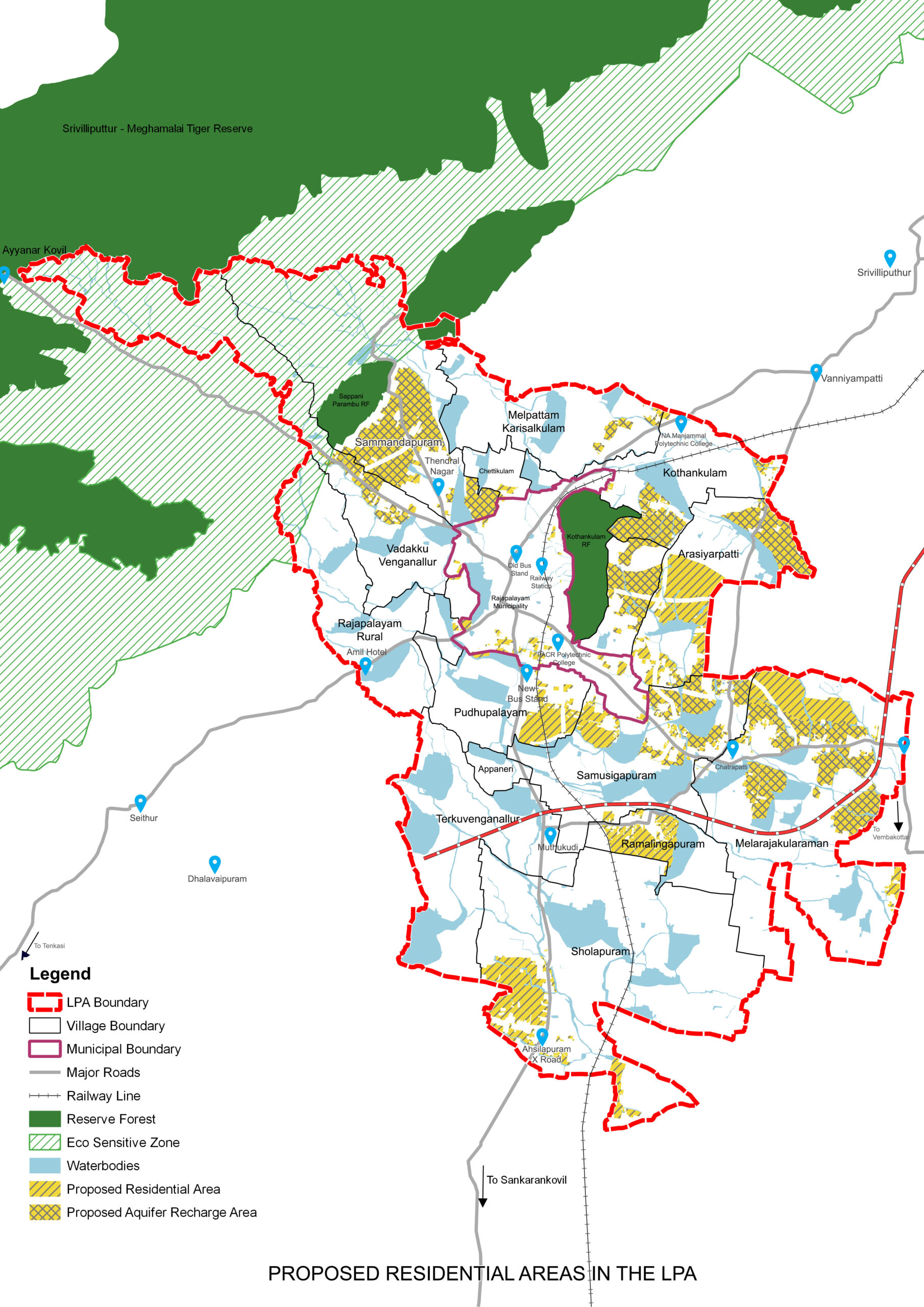
New growth areas for urban extensions are identified around the Municipal area in the villages of Pudhupalayam, Arasiyarpatti, Kothankulam and Sammandhapuram
Phased urban development through Land Pooling and Detailed Development Plans
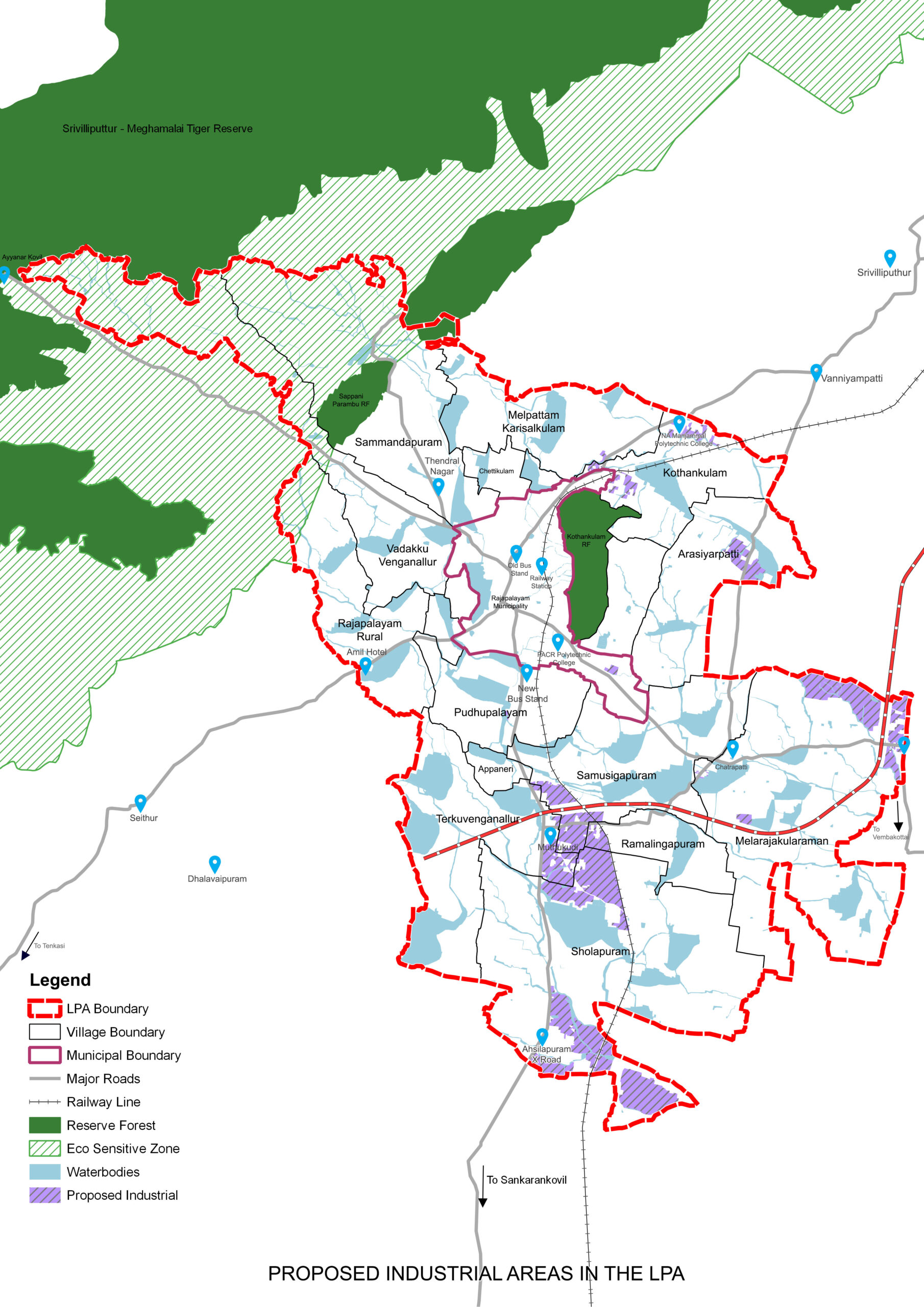
Industrial areas earmarked near Cholapuram and Terkuvengallur, as an extension to SIDCO estate
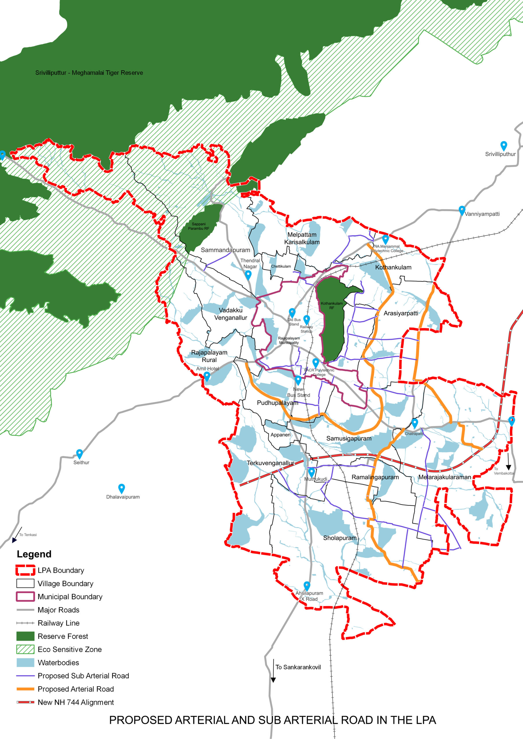
Arterial road (100 feet) and Sub Arterial (80 feet) to solve traffic issues and induce growth
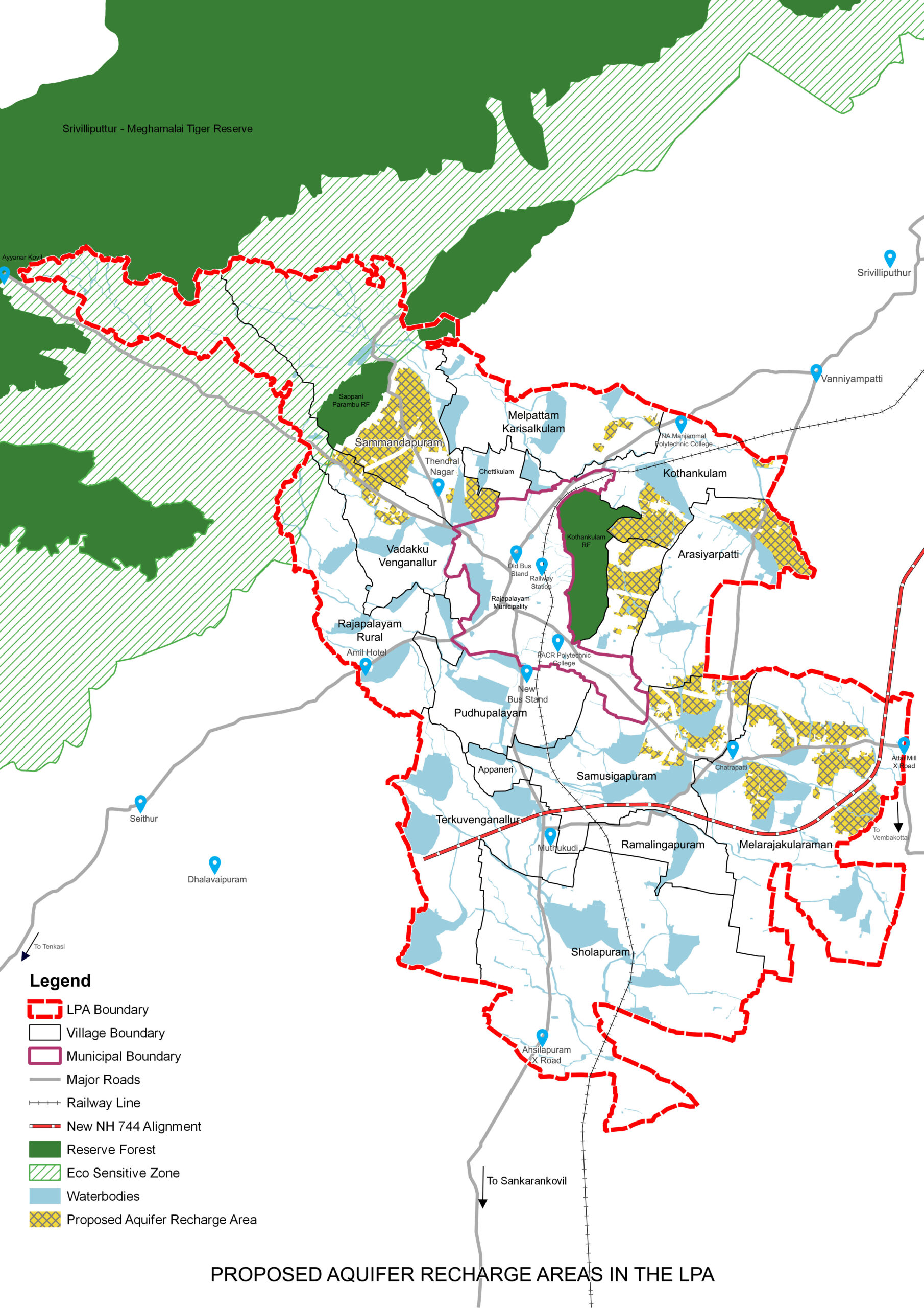
Special emphasis on increasing ground water levels through Aquifer recharge zones
A spatial strategy established in a way to protect 38% of natural Green Blue spaces
All the streams interconnecting the Waterbodies to act as Green Blue walkable corridors to conserve waterbodies and encourage walking
Non-urban spaces used as a shield to protect waterbodies and fertile agriculture lands
Buffers marked for waterbodies & streams, identified as Non-Urban Zones to ensure their protection
Please click text below

Eco sensitive zone norms followed for SMTR to conserve the eco sensitive zone on foot- hills of Western Ghats, to avoid resource degradation and eliminate and any possible human-wildlife conflict
New growth areas for urban extensions are identified around the Municipal area in the villages of Pudhupalayam, Arasiyarpatti, Kothankulam and Sammandhapuram
Phased urban development through Land Pooling and Detailed Development Plans

Industrial areas earmarked near Cholapuram and Terkuvengallur, as an extension to SIDCO estate
Arterial road (100 feet) and Sub Arterial (80 feet) to solve traffic issues and induce growth
Special emphasis on increasing ground water levels through Aquifer recharge zones
A spatial strategy established in a way to protect 38% of natural Green Blue spaces
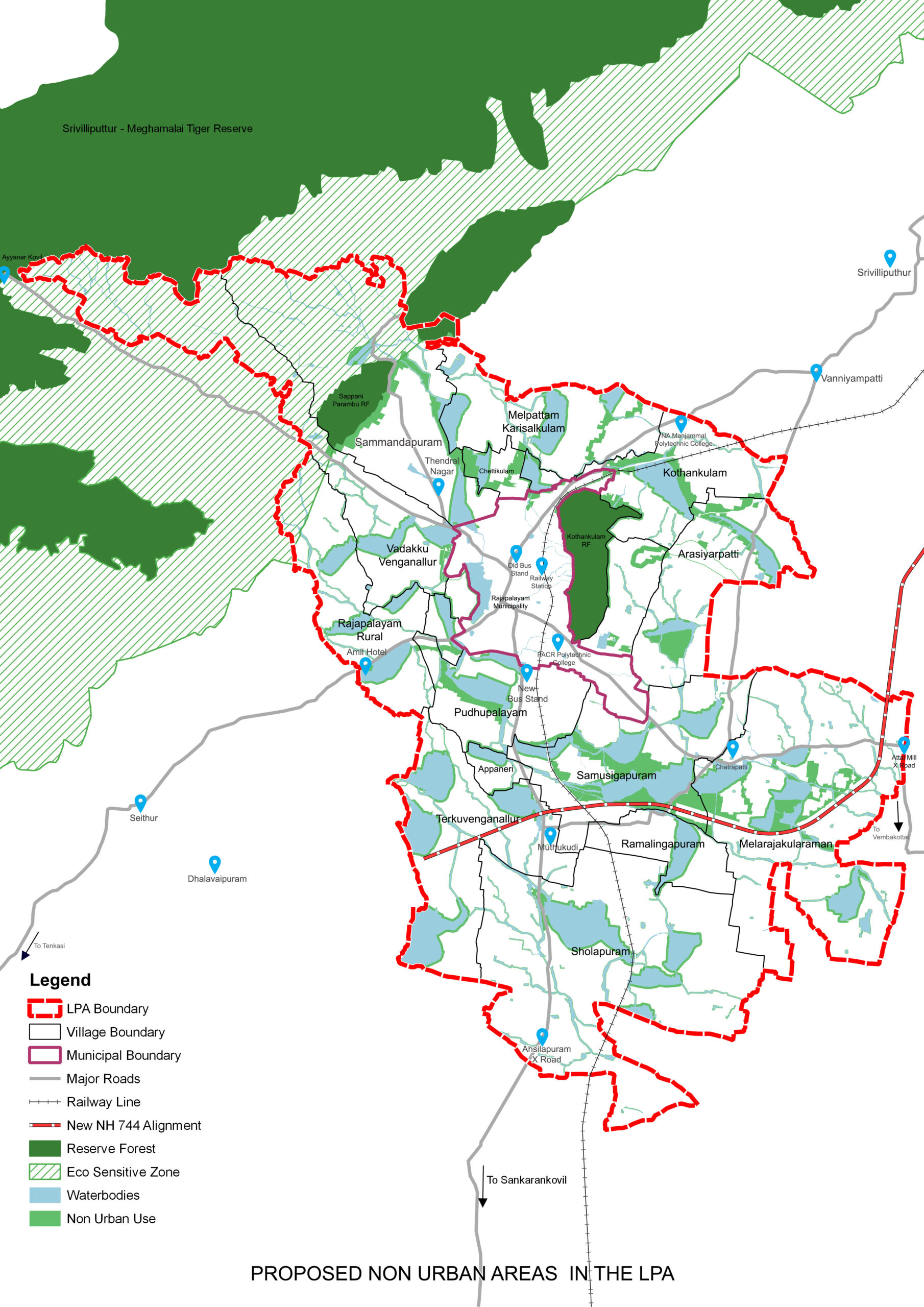
All the streams interconnecting the Waterbodies to act as Green Blue walkable corridors to conserve waterbodies and encourage walking
Non-urban spaces used as a shield to protect waterbodies and fertile agriculture lands
Buffers marked for waterbodies & streams, identified as Non-Urban Zones to ensure their protection
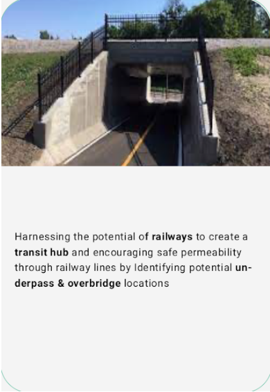
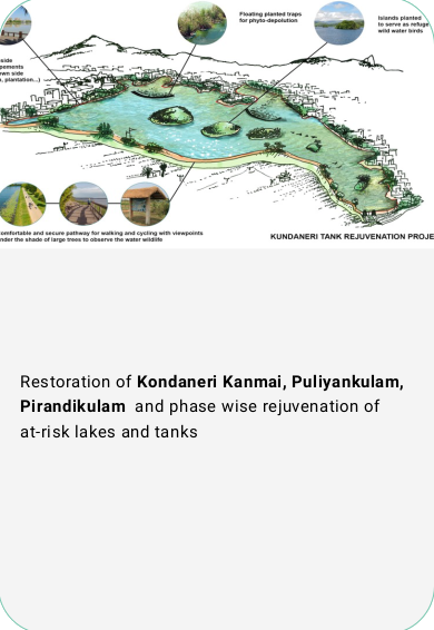
Project Proposals


FAQ
The Master plan is a statutory document that provides a guideline for future growth of town in a sustainable way over a plan period of 20 to 30 years. In Tamil Nadu Master Plan is prepared with the legislative support of Tamil Nadu Town and Country planning Act 1971. The Master plan includes analysis, recommendations, and proposals for a town’s economy, housing, transportation, physical infrastructure, social infrastructure. It is based on public input, surveys, planning initiatives, existing development, physical characteristics, and social and economic conditions. Finally the proposed Land use map is prepared on the basis of future requirements and proposals.
Why is the Master Plan important?
-
As the Master Plan is the document that prescribes land use, development control and building regulations, and policy recommendations that are adopted by different government departments, it plays a crucial role in defining the direction of growth of the city.
-
The Master Plan is important for investors and businesses to identify priority areas of interest and ensure that the development is in line with the government’s vision.
-
More importantly, the Master Plan is important to every citizen as the city’s growth affects everyday matters like the use of natural resources, transport, health, inclusivity, safety, quality of life, access to green spaces, vibrant public spaces, etc
What constitutes the Rajapalayam Local Planning Area?
Rajapalayam Local Planning Area includes the municipal town and 15 surrounding revenue villages and 2 reserved forests. The 15 revenue villages are Appaneri, Arasiyarpatti, Chettikulam, Cholapuram, Kadambankulam, Kothankulam, Melarajakularaman, Melpattam Karisalkulam, Pudhupalayam, Rajapalayam Rural, Ramalingapuram, Sammandapuram, Samusigapuram, Terkuvenganallur, Vadakku Venganallur. The 2 reserved forests are Sappani Parambu RF and Kothankulam RF (Sanjeevi Malai).
How was the current LPA constituted?
Rajapalayam municipal area was declared as Rajapalayam Local Planning Area (LPA) under section 10(1) of the Tamil Nadu Town and Country Planning Act, 1971 by the Department of Rural Development and Land Affairs (RDLA), Govt. of Tamil Nadu, through G.O. Ms. 2012 RDLA, dated 20th September 1973. This was later confirmed under section 10(4) of the Tamil Nadu Town and Country Planning Act, 1971 through G.O. Ms. No. 1374 RDLA, dated 30th May 1974. Rajapalayam LPA was constituted under section 11(1) of the Tamil Nadu Town and Country Planning Act, 1971 in G.O. Ms. No.650 RDLA, dated 8th April 1975.
The intention to add additional areas to Rajapalayam Local Planning Area, with a view to control and channelize the development and growth in Rajapalayam and the surrounding villages was declared by issuing the G.O.(Ms). No. 2014 on 30th December 2011. This was issued under section 10(1) of the Tamil Nadu Town and Country Planning Act, 1971 by the Housing and Urban Development Department, Govt. of Tamil Nadu.
The intention notified additional areas were confirmed as part of the Rajapalayam LPA under section 10(4) of the Tamil Nadu Town and Country Planning Act, 1971 by issuing a G.O. (Ms). No. 168, on 20th November 2014 by the Housing and Urban Development Department, Govt. of Tamil Nadu. The boundary of the composite LPA with the villages and the municipal area approved by the DTCP as mentioned in the G.O. (Ms). No.168/ H&UD, dated 20.11.2014.
Where can I find the Master Plan?
-
The Master Plan is available in the form of reports and maps in the Downloads section of this website.
-
High resolution printed maps and report are available for viewing at:
-
District Town and Country Planning Office, Virudhunagar
-
Municipal Office – Rajapalayam Municipality
-
Participate
We want to know what you think?
We are seeking public feedback on the Master Plan and the proposed future for Rajapalayam LPA.
Take the Survey
View Master Plan
- High resolution printed maps and report are available for viewing at:
-
District Town and Country Planning Office, Virudhunagar
-
Rajapalayam Municipality
Send Your Feedback
-
Deputy Director,
District Town and Country Planning Office,
D.No.BT0, Tamiladu Housing Board Layout,
Madurai road, Chathirareddiyapatti,
Virudhunagar – 626002 -
rajapalayammasterplan@gmail.com
-
+91 75985 06650
Join the Public
Consultation
-
Pethavanalur Mayurnathaswmay Marriage Hall,
Rajapalayam
- 07 Septemper 2023
- 04:00 PM
pin-up casino rəsmi saytı
pin-up casino rəsmi saytı
pin-up casino rəsmi saytı
pin-up casino rəsmi saytı
pin-up casino rəsmi saytı
Mostbet UZ da sport tikishlari va kazino o’yinlari uchun ko’plab turli imkoniyatlar mavjud.
Experimentează distracția și câștigurile garantate la Winmasters Casino, locul unde norocul îți surâde!